
The Centennial Mountains: Our Favorite Places’ Best Kept Secret
Sure, in terms of Rocky Mountain celebrities, the Centennials are not exactly A-listers. Glacier National Park lies to the north; Yellowstone National Park, to the east; Grand Teton National Park, to the southeast.
With backpackers and climbers understandably taken by the Sawtooths, peak-baggers writing their names into registries on Idaho’s ceiling in the Lost Rivers, celebrity skiers and mountain bikers in the Pioneers and Boulders around Sun Valley, and the paddle-bound on the rapids in the Seven Devils and the Frank’s Salmon Rivers, the Centennials enjoy relative obscurity even in Idaho.
Unfortunately, mining companies hope to take advantage of the range’s below-radar status. And for this reason, we need to drag one of Idaho’s shyest and most unique ranges into the spotlight.
Making Our Favorite Places Our Favorite Places
Something that Yellowstone and Glacier and the Tetons all have in common is their current ecosystems depend on the Centennial Mountains. Something that the Lost Rivers and the Sawtooths and the Pioneers and the Boulders and the Seven Devils and the Frank Church Wilderness and all of the central Idaho mountains and wilderness areas have in common is their current ecosystems depend on the Centennial mountains. Something that all of the northern Rockies have in common is that their current ecosystems depend on the Centennial Mountains.


Key Habitat Corridor

Wolves, black bears, cougars, wolverines, lynx, badgers, martens, moose, elk, bighorn sheep, mountain goats (pictured above), mule deer, whitetail deer, pronghorn, and several other mammals depend on the Centennials as their one route between ecosystems. All of these animals make the central Idaho mountains and the western Montana mountains their home to the joy of no few outdoor enthusiasts. To thrive in and contribute to these ecosystems, they need access to large swaths of wilderness. The Centennials provide such access.
Many of these mammals, like bears and wolves and cougars, are keystone species. If they lost access to certain ecosystems, then herding animals would proliferate unchecked, weakening streams by grazing away the vegetation that holds together banks and cleans out toxins and bacteria. By providing keystone species access to their various ecosystems, the Centennials help stabilize watersheds.
Also, a wide variety of birds call the Centennials home. And several migratory birds find the area vital to their long journeys. For example, in 1932, about 35 trumpeter swans, half of the estimated 70 that existed worldwide, were found in the Centennial Valley on the northern side of the Centennials. This discovery led to the Red Rock Lakes National Wildlife Refuge in 1935. “Today,” the U.S. Fish and Wildlife Service reports, “about 46,225 trumpeter swans reside in North America.”
At the risk of waxing sentimental, each time I’m lucky enough to see a swan in flight, I can’t help but see a sky-ballet of gratitude to the Centennials.


Also, three globally rare plants have been found in the Centennials: Railhead Milkvetch (Astragalus terminalis), Beavertip Draba (Draba globosa), and Beautiful Bladderpod (Lesquerella pulchella).
The Continental Divide
The Centennial Mountains’ ridge-line also separates the Pacific-bound waters in Idaho from the Atlantic-bound waters in Montana. A rough 60 miles of North America’s Great Divide dampens the shirt-collars of several backpackers each year on the Continental Divide National Scenic Trail (CDT).

In fact, weirdly enough, the Centennial Mountains give birth to America’s longest river: the Missouri River.

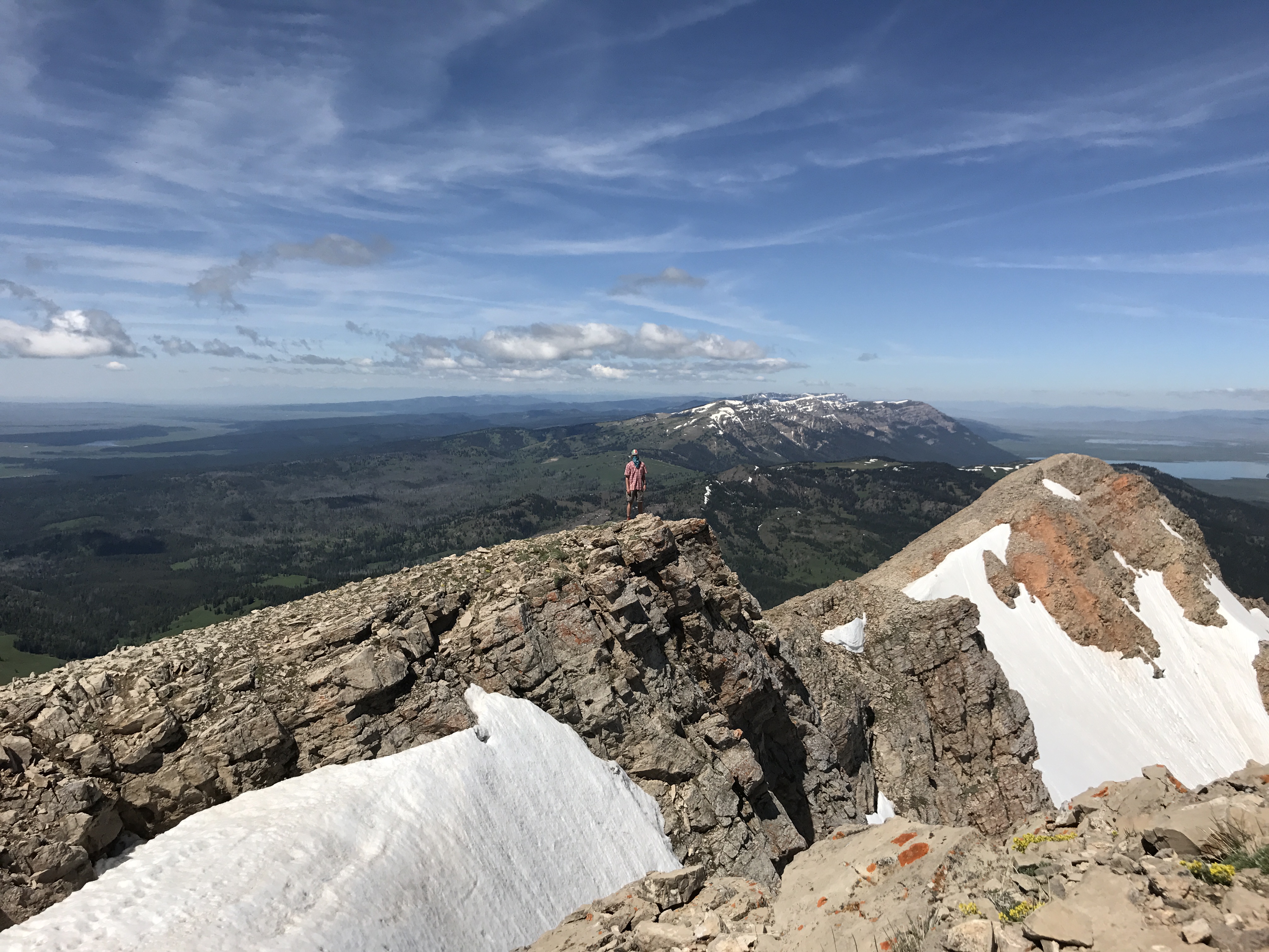
Another unique experience in the Centennials reveals itself in the above photograph. Here in the Hellroaring drainage, we are in Montana, while Idaho lies to the north on the Pacific side of Mount Jefferson’s ridge-line. It’s not often we get to be in Idaho and look south into Montana.
Ridge-line Views Offer Diverse Landscapes
When we peak Mount Jefferson, we are either standing at 10,196 feet elevation according to the Caribou-Targhee National Forests USFS topo, or at both 10,203 and 10,208 peakbagger feet, or at a more stable 10,203 summitpost feet, or at 10,216 Wikipedia feet.

For the entire ridge-line, we can see Montana’s Madison and Tobacco Root ranges to the north, Yellowstone’s massive caldera and Absarokas to the east, Grand Teton’s Tetons to the southeast, Idaho’s vast Snake River Plain to the south and southwest, and Idaho’s Beaverheads and Lemhis to the west.


The Centennial Mountains: A New Favorite Place, Threatened


Logging in Idaho
With old growth Douglas Firs and gentler slopes, Idaho’s side has been heavily logged. Damage to the area due to logging hit the hardest during the area’s 2000 – 2005 drought, weakening their defenses against the devastating bark beetle that is currently killing most of the old Douglas Fir giants that remain.
The Kilgore Project
As if the impact of logging weren’t enough, Otis Gold, a Canadian exploratory drilling company, wants to turn the Centennial Mountains into an open-pit cyanide heap leach mine. They are brazen. The above link to their company website shows their brand’s image as an enormous excavator’s claw in the foreground of mountains.
“In 2018,” the company’s president and CEO says, “we plan to aggressively continue regional exploration work at Kilgore to complement our planned exploration drilling, with a view to potentially further expanding the project” (italics added for shock value).
The U.S. Forest Service is currently reviewing their expansion proposal that would increase their drilling in the Centennials by 33%, adding 3000 more acres of forest-removing roads and 140 more drill sites. Here is how John Robison with the Idaho Conservation League sums up what the CEO means by “a view to potentially further expanding”:
“Otis Gold has said that the deposit is amenable to cyanide heap leach mining. An exploration summary stated that ‘there are no impediments to permitting an open-pit heap leach operation.’ A technical report goes on to lay out future potential for the site: ‘The area features potential sites for processing plant, water storage, heap leach pads and facilities.'”
Robison further points out that the proposed expansion would include three new drill rigs operating 24/7 from June through November. The noise pollution alone could prove disastrous for various animals depending on their key habitat corridor. Animals have developed PTSD from loud industrial buzz shaking their natural homes. And Idaho’s own most endangered animal, the lowland caribou, has nearly gone extinct (11 left is all) due to the noise of snow mobiles scaring them out of their lichen-rich forests.
Robison highlights how the project would affect two more drainages in the Centennials, endangering the surface and ground water. “Ironically,” Robison says, “open-pit cyanide heap leach mining is banned just a few miles to the north in the state of Montana after a series of accidents poisoned wells and left taxpayers with enormous cleanup costs.”
I could not imagine the damage a cyanide leak could have on the Continental Divide: poisoned streams from the Pacific to the Atlantic. To quote Winona LaDuke,
“Someone needs to explain to me why wanting clean drinking water makes you an activist, and why proposing to destroy water with chemical warfare doesn’t make a corporation a terrorist.”

Below: Drilling at one of the Kilgore sites in the Centennial Mountains. [PC: Otis Gold]

Below: Kilgore Project clearing forest away to drill. [PC: Otis Gold]

Below: An open-pit cyanide heap leach mine. [PC: Homestake Mining]

Below: What a forest looks like when it is gone.
If the U.S. Forest Service grants Otis this drilling expansion, our ecosystems in the northern Rockies may never be the same.
Dale Baldwin
February 12, 2018Great job Alex! I love the comparisons to the way things are and should be to the way things will be and never should be.These pictures alone should be enough to convince any sane person of our responsibility to keep nature as it was intended.
Dale B
Alex
February 12, 2018Thanks, Dad!!!
Bk
September 4, 2022Lived and worked in Island Park. My cabin was at the base of Sawtell!!! I could add many chapter to that… Great Article and pictures!!!!